Utility & Infrastructure
Documentation App
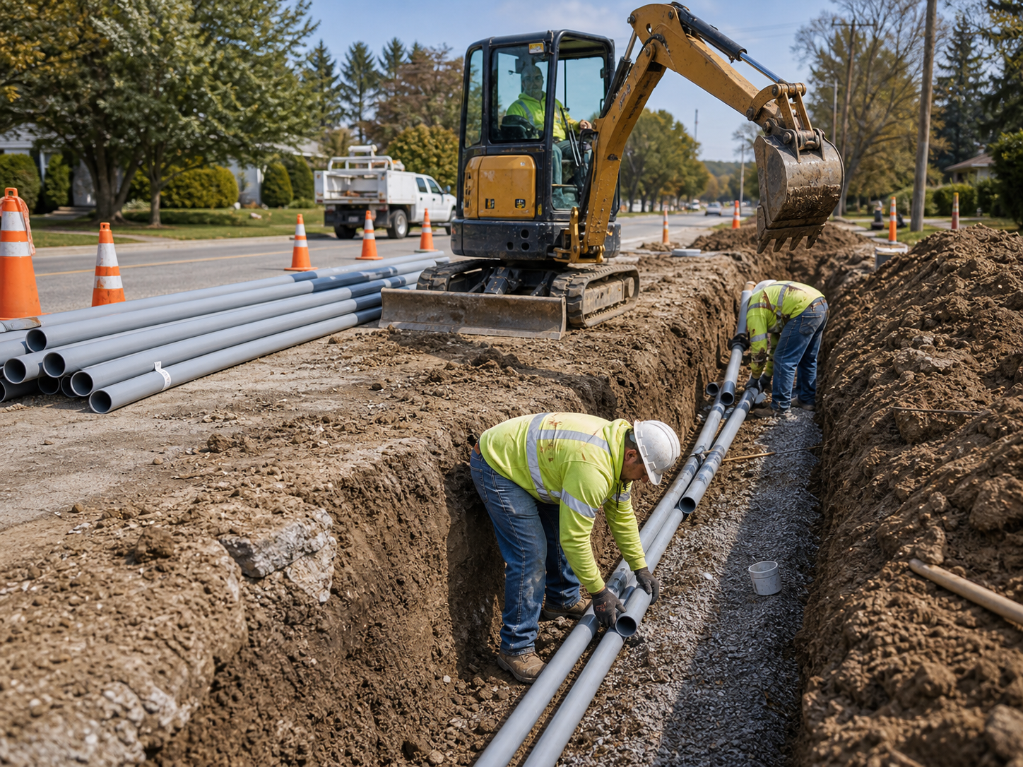
Document burial depth, bedding, and route conditions: geotagged proof of underground work that survives backfill, audits, and future excavators.
Trusted by 1,200+ field contractors across the trades.
Without Documentation, You're Exposed
Utility contractors bury their work and answer for it decades later. Here's what's at stake.
As-Builts That Don't Match Reality
Burial depth, separation, bedding, conduit count: once the trench is backfilled, the record is whatever someone wrote down. When a future excavator hits your line or the owner audits as-builts, photos are the only ground truth — and not having them is expensive.
Damage Claims From the Public
Work in the right-of-way means working next to driveways, fences, irrigation, and landscaping you didn't touch — until someone says you did. Without pre-construction photos along the route, every claim from an adjacent property owner becomes a payout.
Agency & DOT Compliance Exposure
Traffic control plans, trench safety, restoration specs: agency inspectors expect proof, not promises. Records scattered across crew phones won't survive a DOT audit or a prevailing-wage project review.
How It Works
Three simple steps to organized, professional documentation.
Document the Route First
Capture pre-construction conditions along the alignment: pavement, driveways, landscaping, existing utilities, locate marks. Every photo automatically timestamped and geotagged.
Record Work Before Backfill
Photos organized by job and stage: locates, trenching, bedding, conduit and pipe placement, depth checks, backfill, compaction, restoration. GPS ties each photo to the station.
Report & Share
Generate professional PDF reports in minutes. Send daily records to agencies, engineers, and primes straight from the field.
Built for Utility & Infrastructure Contractors
Every feature designed to save you time and protect your business.
Geotagged Route Photos
Every photo captures date, time, and GPS automatically — on linear work, the location stamp is the difference between "somewhere on the job" and station-accurate as-built evidence.
Utility Stage Categories
Organize photos by phase: pre-construction, locates, trenching, bedding, placement, backfill, compaction, vaults and structures, surface restoration.
Agency-Ready Reports
Generate PDF reports for daily work records, as-built supplements, and restoration documentation. Formatted to satisfy agency inspectors and prime contractors.
Automatic Cloud Backup
Every photo backed up automatically. Infrastructure disputes surface decades later — your records will still be there.
Share with Agencies & Primes
Send reports and photos to agency inspectors, project engineers, and prime contractors via email or text link, same day as the work.
Built for the Right-of-Way
Fully offline capable — rural alignments rarely have coverage. Capture with gloves on, organize from the truck, sync back in town.
Real-World Use Cases
See how utility & infrastructure contractors use Fieldpost on every job.
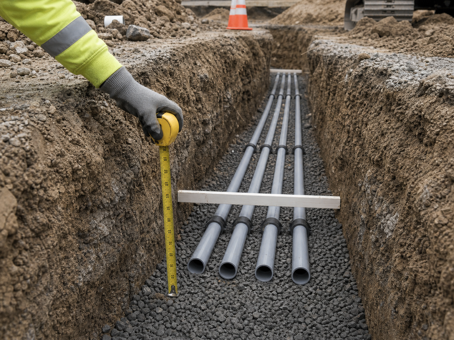
Burial Depth & Bedding Records
Photograph every run before backfill: tape measure showing cover depth, bedding material, conduit separation, warning tape placement, tracer wire. When a future contractor strikes your line and claims it was shallow, your geotagged photos prove the burial met spec at that exact location. For duct banks and casings, the pre-pour photos are the permanent record of what's inside.
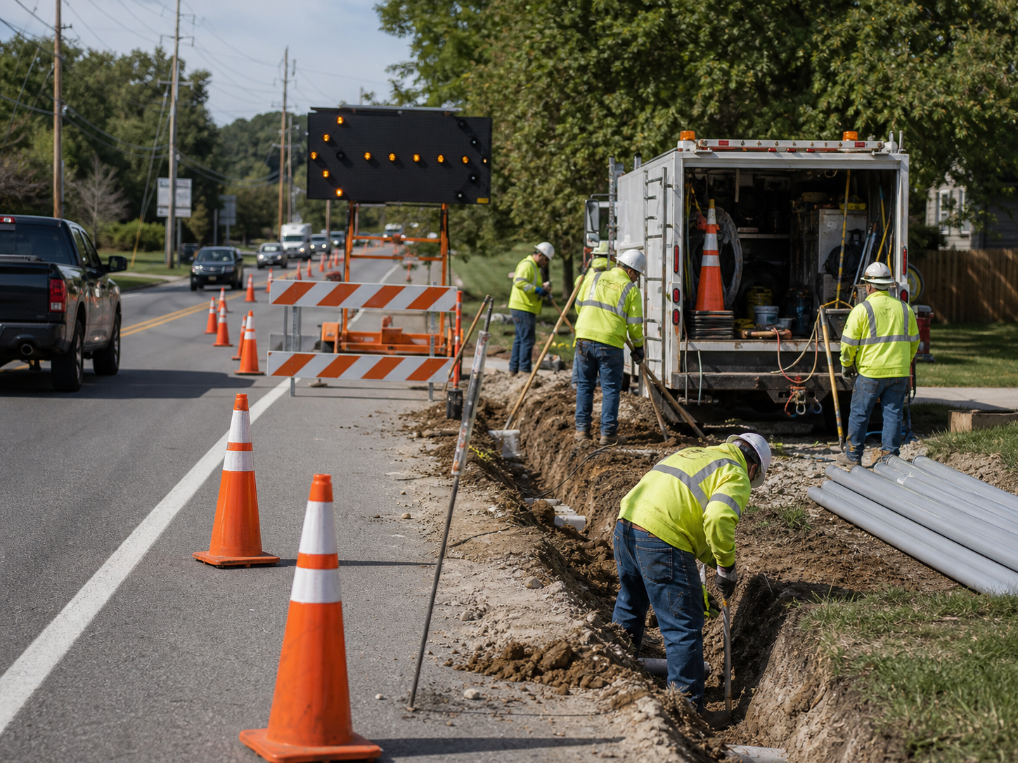
Daily Records & Traffic Control Compliance
Document each day's setup and progress: signage and channelization per the traffic control plan, trench protection in place, crew and equipment on site, stations completed. When the agency questions an invoice, an incident occurs in your work zone, or a DOT auditor calls, your daily photo record answers in minutes what would otherwise take depositions.
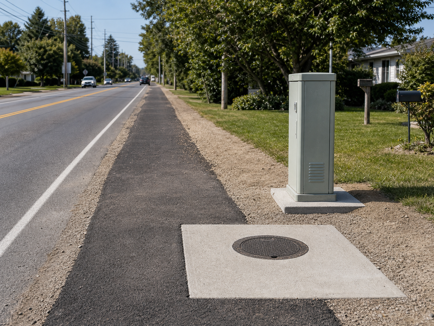
Restoration & Closeout Documentation
Photograph pre-construction surface conditions along the route, then the finished restoration: pavement patches, sidewalk panels, topsoil and seed, mailboxes back in place. Property owner claims along a utility alignment can trickle in for a year — dated before-and-after photos at each address close them immediately and keep your restoration bond clean.
Backfill is permanent. So is your photo record.
30 days free. Document your next run before the trench closes.
Start Free TrialFree for 30 days. No credit card required.
Frequently Asked Questions
Questions utility & infrastructure contractors ask before getting started.
Can the photos serve as as-built documentation?
They're the strongest as-built supplement there is. Every photo is geotagged and timestamped, so depth and placement records tie to actual coordinates. Many crews photograph the tape measure in the trench at regular stations — that record outlives any red-line drawing.
Most of our alignments have no cell coverage. Does it work?
Yes. Fieldpost works fully offline. Capture photos, add notes, and organize by job anywhere on the route. Everything syncs automatically when you're back in coverage.
How does this help with public damage claims?
Photograph conditions along the route before construction: every driveway, fence, and lawn in the work zone. When a resident claims your crew cracked their driveway, the dated pre-construction photo answers it in one email. Utility contractors that document routes stop writing goodwill checks.
Can I produce a daily work record for the agency inspector?
Yes, in under 2 minutes. Photos are already organized by date and stage — select the day, generate the PDF, and email it to the inspector before you leave the site.
How is this different from the camera roll on my phone?
Camera roll photos aren't organized by project or station, vanish with broken phones and crew turnover, and can't prove location along a five-mile alignment. Fieldpost organizes and geotags everything automatically and generates agency-ready reports in minutes.
Can I add multiple crews to one account?
Yes. Plans start at 3 users for $25/month, with additional users at $10/month. Every crew documents to the same projects in real time. No annual contracts.
Common Utility & Infrastructure Contractors Workflows
See how utility & infrastructure contractors document specific scenarios.
Waterproofing & Underground Documentation
Depth, bedding, and separation proven before backfill.
Learn morePre-Existing Damage Documentation
Every driveway and fence along the route, documented before work starts.
Learn moreDaily Jobsite Progress Tracking
Daily records that satisfy agencies and primes.
Learn morePermit & Code Compliance
Traffic control and trench safety compliance, photographed.
Learn moreSafety & OSHA Documentation
PPE, hazards, and safety walks documented before OSHA asks.
Learn moreEquipment & Fleet Documentation
Condition records for every machine, trailer, and tool.
Learn moreOther Trades We Serve
Fieldpost is built for teams across the trades.
Excavation & Sitework Contractors
Utility locates, grade verification, and buried-work documentation before backfill.
View industry pageMunicipal & Public Works Contractors
Daily work records for agency inspectors and photo evidence that defeats citizen damage claims.
View industry pageConcrete & Paving Contractors
Pre-pour records, subgrade prep, and proof your flatwork was placed to spec.
View industry pageHeavy Equipment Rental & Service
Delivery and pickup condition reports that end rental damage disputes.
View industry pageLow Voltage & Security Contractors
Cable pathway records before drywall, rack documentation, and as-built photos for service calls.
View industry pageStart Documenting Your Utility Work Today
Join utility and infrastructure contractors that protect their business with geotagged photo documentation.
Free for 30 days. No credit card required.